News Releases
Orefinders Outlines Summer Exploration Program for McGarry Project
Orefinders Outlines Summer Exploration Program for McGarry Project
Toronto, Ontario – April 11, 2019 – Orefinders Resources Inc. (“Orefinders” or the “Company”) (TSX.V: ORX) is pleased to announce its planned work program for its McGarry Mine project along the Cadillac-Larder Lake Break (“CLLB”) near Kirkland Lake, Ontario.
Since acquiring McGarry and Barber Larder in August 2018, Orefinders has focused its activities on compiling all the historical data, spanning numerous decades, to develop a work plan that evaluates high potential zones. This is in line with Orefinders’ strategy of consolidating and developing the Cadillac-Larder Lake Break, on which McGarry and Barber Larder properties share synergies with Orefinders’ Mirado Mine located 15KM to the southwest.
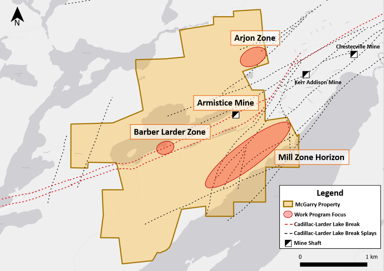
Map of the McGarry Exploration Program Focus Areas
“Developing gold resources geographically around the McGarry property is part of our core strategy. I’ll note that Mirado is only 15 KM away and that McGarry hosts an existing large tailings facility along with the infrastructure required to build a mill facility. Our goal is to increase resources that exist within a tight radius of this hub. We’ve completed some toll milling and evaluated new contracts but ultimately Orefinders wants to control its own destiny. We have acquired a number of the key elements and this plan is designed to grow our own critical mass to justify our own operations,” said Stephen Stewart, Orefinders’ Chief Executive Officer.
Focus on Splay faults from Cadillac-Larder Lake Break
An important proportion of the resources in the Kirkland Lake-Larder Lake mining district were discovered and mined on subsidiary structures emanating from the CLLB. These splay faults host the mineralization in the South-Mine Complex at Kirkland Lake Gold’s Macassa Mine and are responsible for the mineralization in the Mill Horizon trend at the Kerr Addison mine and south of the Armistice mine on the McGarry Property.
It is very clear from our air photo lineament analysis that the Arjon Structural Trend represents such a splay north of the CLLB and could represent a transfer fault between the CLLB and the north contact of the Temiskaming sedimentary basin. These targets on the McGarry Property have seen much less drilling than the CLLB itself and they are known to host gold mineralization and have excellent potential for discovery of near surface gold zones in unconventional environments as underlined by the South Mine Complex discovery.
Potential at the Armistice Mine on McGarry
When underground mining operations at the Armistice mine were suspended in 2013 the project was left with historical indicated resources of 446,000 tonnes at 8.6 gpt gold for 123,000 ounces (7.9 gpt gold, cut to 51 gpt) and an additional inferred resource of 156,000 tonnes at 5.8 gpt gold for 30,000 ounces (see Armistice Resources Corp 2011 Technical Report on McGarry Project at www.sedar.ca) (See note on Historical Resource Estimates below).
Three principal mineralized zones have been mapped in the Armistice mine:
- The Kerr Zone, which is the northern-most of the three, is interpreted to correlate with the main flow ore on the Kerr Addison Mine to the east. It is hosted in strongly deformed mafic volcanics described as cherty mudstones. Grades up to 15.0 gpt over narrow intervals occur within a 10 metre-thick package of altered and silicified rock starting just below the 2,250-feet level of the Armistice mine. The overall geology is steeply dipping to the north and the Kerr Zone plunges about 70 degrees to the southwest, the same rake as the Kerr Addison deposits.
- The parallel Sheldon and the Armistice zones are located to the south of the Kerr Zone and correlate with the Mill Zone Horizon on the east side of the Armistice fault, against which the mineralization at Kerr Addison terminates and which has been interpreted to have a 610 metres west side down displacement placing the top of the same horizon at nearly 2,000 metres vertical depth.
Potential at the Barber Larder
Barer Larder hosts shallow, high-grade mineralization, thus warranting an aggressive drill program given its location on the Cadillac-Larder Lake break. A small open pit operation in 1987-88 produced 77,000 tonnes of material and was sent to the Kerr Addison mill at an average grade of 4.1 gpt gold. However, only the top most part of the deposit was mined and as such, a significant amount of mineralized material remains. Drill intersections that project beneath the pit include:
- 42.7 gpt gold uncut (20.6 gpt Au cut to 30 gpt gold) over 2.4 metres in hole B88-35 drilled in 1988.
- 14.2 gpt gold over 3.9 metres in hole BL-80-29 drilled in 1980.
These drill results need to be validated based on resampling of core remaining in the core library at the Armistice Mine, which is planned in the coming months. Future exploration on the Barber-Larder Zone will seek to complete a proper interpretation of the mineralized zone and validate whatever assays are available.
Furthermore, ~600m west of the Barber-Larder zone, a drill hole intersected 6.1 metres grading 3.4 gpt gold at a vertical depth of 60 metres in the same package as Barber-Larder. We plan on following up on this by conducting shallow drilling between the Barber-Larder Zone and the western boundary of the property.
Potential at the Mill Zone Horizon
The Mill Zone Horizon is located south of the Armistice mine and extends over 3,000 metres parallel to the CLLB, straddling the McGarry and Kerr Addison properties. Gold is hosted in quartz veins in green carbonate altered ultramafic units intercalated with mafic volcanics and sedimentary rocks. Grades up to 7.2 gpt gold over 7.8 metres were encountered on surface and in shallow drilling. Mapping and trenching is proposed for this area to better understand the structural controls on the mineralization found in the Mill Zone.
Potential at the Arjon Zone
The Arjon Zone is located north of the Armistice mine and is comprised of intercalated mafic and green carbonate altered ultramafic volcanics and numerous syenite porphyry intrusions. The rocks are sheared and altered, particularly in the vicinity of the green carbonate units and there is ample evidence of low angle, secondary fault structures emanating from the Cadillac-Larder Lake break and extending northeast, linking up the break with unit parallel faulting on the north side of a Temiskaming-type sedimentary basin. Very little work has been done in this area since the original mapping in the late 1930’s but a recent air photo lineament study indicates numerous potentially mineralized structures crossing this favourable package of rocks. The plan is to conduct mapping and prospecting along the Arjon Fault System to better understand the structures and controls of gold mineralization. Recent discoveries by Kirkland Lake Gold in the South Mine Complex underlines the important of off break environments as favorable targets for gold exploration in the Kirkland Lake-Larder Lake district.
About McGarry Mine Project
The McGarry Project contains several mineralized zones including a historical resource on the Armistice Mine. Established mining infrastructure comprises a 34 metre headframe, a 3-compartment shaft to 700 metres depth with two 6 ft by 6 ft hoisting compartments equipped with a service cage and a 4.5 tonne skip, respectively. The Shaft is serviced by a 3.0 metre diameter double drum hoist capable of hoisting over 900 tonnes per day.
The McGarry project straddles the Cadillac-Larder Lake Break and is located immediately west of the Kerr Addison Mine which produced over 11 million ounces of gold between 1938 and 1996. The McGarry property is underlain by the same sequence of rocks as found on the Kerr Addison property and hosts similar mineralization types including “flow ore” and “carbonate ore”.
Note on Historical Mineral Resources
There are no current Mineral Resource or Mineral Reserve estimates prepared for the McGarry Property. However there have been a number of historic estimates prepared over the years. Orefinders cautions that a qualified person has not done sufficient work to classify the historic estimates as current mineral resources or mineral reserves and the historical estimates should not be relied upon. Orefinders consider these results as indications of the presence of mineralization on the property and we will use the information to guide future exploration but the reader is cautioned not to rely on these estimates.
About Orefinders Resources Inc.
Orefinders is a Gold exploration and development company focused exclusively within the Abitibi Greenstone Belt. The Company is listed on the TSX Venture Exchange under the symbol ORX.
QP Statement
The technical information contained in this news release has been reviewed and approved by Charles Beaudry, P.Geo, Director and Vice President Exploration for Orefinders, who is a Qualified Person as defined in “National Instrument 43-101, Standards of Disclosure for Mineral Projects.” Reports on mineralized intersections are based on available documents and in many cases there is no way to verify the quality of the assays and certificates of analyses may not be available. We caution the reader that these intersections are only used to orient future exploration and where old core boxes are available the core will be resampled with strict QAQC protocols in order to validate the historical results.
For the latest updates please contact or follow us on Twitter @OrefindersR
To Speak to the Company directly, please contact:
Stephen Stewart, Chief Executive Officer
Phone: 416.644.1567
Email: sstewart@orefinders.ca
Neither TSX Venture Exchange nor its Regulation Services Provider (as that term is defined in the policies of the TSX Venture Exchange) accepts responsibility for the adequacy or accuracy of this release. Certain information in this press release may contain forward-looking statements. This information is based on current expectations that are subject to significant risks and uncertainties that are difficult to predict. Actual results might differ materially from results suggested in any forward-looking statements. Orefinders’ assumes no obligation to update the forward-looking statements, or to update the reasons why actual results could differ from those reflected in the forward looking-statements unless and until required by securities laws applicable to Orefinders. Additional information identifying risks and uncertainties is contained in filings by Orefinders with Canadian securities regulators, which filings are available under Orefinders’ profile at www.sedar.com