News Releases
Orefinders Closes McGarry Mine & Larder-Lake Project Acquisition
Toronto, Ontario – August 20, 2018 – Orefinders Resources Inc. (“Orefinders” or the “Company”) (TSX.V: ORX) is pleased to announce that it has closed its McGarry Mine & Larder-Lake project acquisition as described in the Company’s April 3rd, 2018 News Release.
“We were able to acquire the McGarry Mine & Larder-Lake projects that were previously tied up in litigation and environmental issues and we have since come to an agreement with the Province which effectively eliminates the issues impeding development of the region. With this acquisition, Orefinders has acquired a very high-grade resource which has substantial exploration upside. We’ve also acquired the data from over 100,000 metres of drilling along with substantial geophysics. In the near term, we will be releasing our new interpretations, geological model and exploration plan for this asset and others. This is the type of acquisition that falls directly inline with our philosophy of finding new deposits on old mines,” said Stephen Stewart, Orefinders’ Chief Executive Officer.
About McGarry Mine & Larder-Lake Project
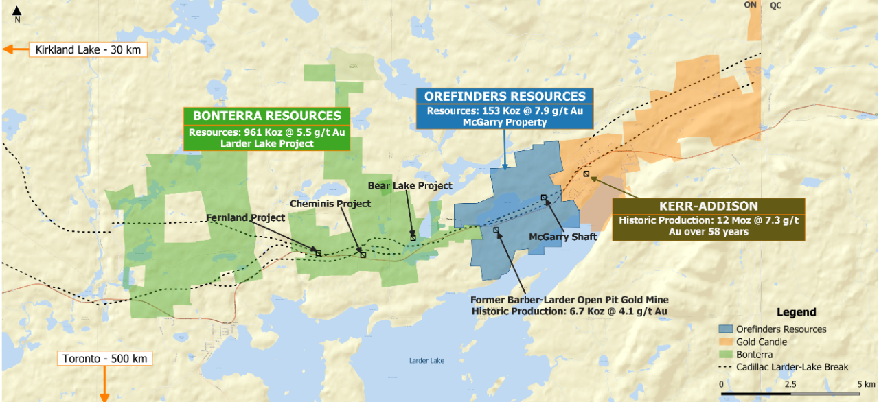
The McGarry Mine & Larder-Lake project is in Virginiatown, Ontario within the Abitibi Greenstone Belt and spans 3.0km on one of the world’s most prolific gold structures, the Cadillac Larder-Lake Break. The property encompasses 681 hectares and is comprised of 46 Patented Mining Claims and 5 Mining Licenses of Occupation. On site infrastructure includes a head frame, shaft with compartments, hoist, offices, and fully functional core shack all refurbished over the last ten years. McGarry is easily accessible with the Trans-Canada Highway running directly through the property.
McGarry Historical Mineral Resources
The McGarry Property was the subject of a PEA study in 2011 that outlined a historical mineral resource of 447,000 tonnes grading 7.89 gpt gold for a total of 112,000 gold ounces in the Indicated Category and an additional 157,000 tonnes grading 5.83 gpt gold for a total of 29,000 ounces in the Inferred Category as listed in Table 1 below.
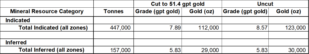
| Table 1: McGarry Historical Mineral Resource Estimate, Armistice Resources 2011 Technical Report |
This estimate was based on a 3.43 gpt Au lower cut-off with assay grades limited to 51.4 gpt gold. A specific gravity of 2.79 grams per cubic metres was used along with a minimum horizontal mining width of 1.5 metres. The report is available at www.sedar.ca under Kerr Mines Inc. and its amended version was published on 30 September 2011. Please note that these are historical mineral resources and should not be relied upon since an Orefinders’ Qualified Person has not undertaken the necessary work to establish any Mineral Resources or Mineral Reserves as defined in NI43-101. Refer to the disclaimer at the end of this news release for more details.
McGarry Production and Infrastructure
As recently as 2013 the McGarry Mine was in production from significant underground workings and was undergoing underground exploration. Kerr/Armistice spent considerable capital upgrading McGarry’s infrastructure including the shaft, hoist and onsite facilities necessary to extract ore from underground. Additionally, extensive underground exploration yielded outstanding grades over very long drift lengths, including:
325 N Zone – 2280 sublevel
- 8.2g/t gold over 98m length and 1.5m width, Stope #1 (E & W)
- 4.6 g/t gold over 26m length and 1.3m width, Stope #1.5 (E & W)
- 7.6 g/t gold over 79.2m length and 1.4m width, Stope #2 (E & W)
325 N Zone – 2330 sublevel
- 11.1 g/t gold over 24m length and 1.7m width, Stope #1 (E)
- 6.1 g/t gold over 7.6m length and 1.2m width, Stope #2 (E)
- 4.3 g/t gold over 7.6m length and 1.8m width, Stope #2 (W)
440 N Zone – 2250 level
- 6.2 g/t gold over 18m length and 1.6m width
The above exploration results and grades include 35% dilution and are reported from Kerr Mines news release April 22, 2013 which is available on Sedar.com.
McGarry Exploration Potential
The McGarry Property is host to numerous gold mineralized zones and many have only been drilled to relatively shallow depth. The following is a short summary of potential targets on the Property that merit follow-up.
McGarry Mine
Development work by the previous owners has prepared the 325N Zone for production. This zone is of particular interest because of its high grades as described above.
Exploration on the McGarry Deposit was quite extensive in and near the existing mining infrastructure but generally outside the area of the shaft between the 1,250 and 2,250 ft levels exploration has been a lot less intensive. Considering the abundant underground infrastructure, the targets that can be pursued can be quite small. In particular, between the shaft and the eastern limit of the Property, there is ample room for discovery and the proximity of the historic Kerr-Addison mine opens up the possibility of deep extensions of that deposit on the west side of the Armistice Fault as suggested by north side down movement along the Larder Lake Break (see MNDM OFR5831).
Barber-Larder Open Pit
The McGarry Property also hosts the Barber-Larder open pit which produced 70,000 tonnes of materials, of which approximately 51,000 tonnes were processed at the Kerr Mill which returned a total of 6,700 ounces of gold for an average reconciled grade of 4.1 gpt gold (see MNDM AFRI file 32D04SE0006). This area of the property and its historical production are distinct from, although abutting, the production and resources on the McGarry shaft zone.
Barber-Larder Extensions
The Barber-Larder deposit was mined as a small open-pit by Golden Shield Resources between November 1987 and July 1988. Production bottomed out at approximately 46 metres. However, the deposit continues below at similar grades (see MNDM, AFRI 32D04SE0006). Moreover, beyond the top 120 metres vertical the deposit has not been much explored and there are indications of significant gold mineralization down to at least 600 metres vertical where a hole intersected a narrow 30 cm core length interval at 11.7 gpt gold.
To the west of the Barber-Larder deposit, previous exploration identified a number of targets that merit follow-up. Approximately 150 metres grid-west of the shaft a hole intersected 1.8 meters grading 3.4 gpt gold. 30 metres grid-east of this, another hole intersected 3.9 gpt gold over 3.5 metres.
Approximately 25 metres east of the open pit a hole intersected a 7.9 metre interval grading 7.5 gpt gold and although there is only 330 metres between the eastern end of the old workings in the Barber-Larder mine (120 metres) and the western end of the 2,250 foot level in the McGarry Mine the vertical distance is over 550 metres. Within this envelope there is ample room for exploration.
Peninsula Zone
The Peninsula Zone is located immediately west of the Barber-Larder Mine along the same package of deformed and altered rocks. A hole drilled near the peninsular island returned 3.4 gpt gold over a core interval of 6.1 metres at a vertical depth of 85 metres (see MNDM AFRI 32D04SE0006).
Mill Zone and Western Zone
The Mill and Western Zones are located in a northeast striking ultramafic unit that has been completely altered to carbonate. The Mill Zone is located at the southern end of the 750m long ultramafic unit and is cut off by an east-northeast trending fault. Drilling on this zone intersected up to 36.7 gpt gold over 2.1 metres.
The Western Zone is located near the northeastern end of the same altered ultramafic unit. The zone was trenched over 75 metres in length and indicated the presence of a small mineralized shoot approximately 15 metres long and 1.7 metres wide and assaying an average of 3.9 gpt gold (see MNDM AFRI 32D04SE0402).
Dyke Zone
The Dyke Zone is located in the southeastern corner of the McGarry Property and is hosted by an altered diorite or gabbro. The NE trending dike is fractured in places and contains quartz and calcite stringers with pyrite. The zone extends for over 300 metres and was sampled over about 100 m giving an average of 7.25 gpt gold over about 1.0 metres in width (see MNDM AFRI 32D04SE0402).
Lamprophyre Zone
The Lamprophyre Zone is located on the southeastern corner of the Property and is hosted by mafic volcanics of the Temiskaming Assemblage. The mineralized zone consists of a NE trending shear at the contact of a lamprophyre dike. Values up to 3.9 gpt gold are reported over 0.9 metres (MNDM, ARV050).
Arjon Zone
The Arjon Shear Zone is located in the northeast corner of the McGarry Property and extends to the northeast onto the adjacent Kerr Property. There are a few drill holes marked on a 1941 map (MNDM ARV50, MDC03) and mapping indicates the presence sheared ultramafics rocks transformed to green carbonate. The map also shows some NE trending quartz veins several tens of metres long but no assays. None of these drill holes were compiled by later explorers and are of uncertain origin. The Arjon Shear is oriented NE and cuts the Blake River mafic volcanics, some altered Ultramafic Units, and the syenite porphyry. Only low grade gold values (up to 2.8 gpt Au) were found on the occurrence as there was generally no interest in the past for bulk-minable targets little work was done after the 1930’s. On the adjacent Kerr property there is a description of a “Northern” crosscut that was driven on the 2,500 foot level across the Temiskaming sediments into some mafic volcanics which are presumably the Blake River Assemblage. This reference describes a 400 foot (122 metres) section of drifting in altered and sheared volcanics that assayed a minimum of 200 ppb over the whole interval with some higher grade sections within.
This target needs to be followed-up for its potential for intrusion-hosted bulk-minable gold mineralization.
Orefinders Payment to Kerr Mines
Orefinders has delivered the purchase consideration to Kerr Mines Inc.(“Kerr”) being 8 million of its common shares. Additionally, Kerr will receive 440,248 shares in PowerOre Inc. as the Kerr/Orefinders transaction was agreed to prior to Orefinders Plan of Arrangement with PowerOre. The 8 Million Orefinders shares are subject to a lock up agreement with Kerr and are scheduled to be free trading over a two-year period.
About Orefinders Resources Inc.
Orefinders is a Gold exploration and development company focused exclusively within the Abitibi Greenstone Belt. The Company owns all of its assets 100% and is listed on the Toronto Venture Exchange under the symbol ORX.
Cautionary Statement
The McGarry Project contains a historic mineral resource estimate. Python Mining Consultants Inc. was commissioned by Armistice Resources Corp (now Kerr Mines) to prepare a mineral resource estimate as reported in a technical report titled “Technical Report and Mineral Resource Estimate McGarry Project, McGarry Township (Virginiatown), Ontario”. This report was published on 8 April 2009 and was amended on 30 September 2011. Orefinders considers the historical estimate to be relevant and reliable given that it was prepared under NI 43-101 standards. However, Orefinders considers this resource estimate to be historical as it has not independently verified it, and therefore it cannot be relied upon as a current mineral resource for Orefinders. A qualified person of Orefinders has not done sufficient work to classify the historical estimate as current mineral resources or mineral reserves and as such, Orefinders is not treating the historical estimate as current mineral resource.
QP Statement
The technical information contained in this news release has been reviewed and approved by Charles Beaudry, P.Geo, Director and Vice President Exploration for Orefinders, who is a Qualified Person as defined in “National Instrument 43-101, Standards of Disclosure for Mineral Projects.”
For the latest updates please contact or follow us on Twitter @OrefindersR
To Speak to the Company directly, please contact:
Stephen Stewart, Chief Executive Officer
Phone: 416.644.1567
Email: sstewart@orefinders.ca
Neither TSX Venture Exchange nor its Regulation Services Provider (as that term is defined in the policies of the TSX Venture Exchange) accepts responsibility for the adequacy or accuracy of this release. Certain information in this press release may contain forward-looking statements. This information is based on current expectations that are subject to significant risks and uncertainties that are difficult to predict. Actual results might differ materially from results suggested in any forward-looking statements. Orefinders’ assumes no obligation to update the forward-looking statements, or to update the reasons why actual results could differ from those reflected in the forward looking-statements unless and until required by securities laws applicable to Orefinders. Additional information identifying risks and uncertainties is contained in filings by Orefinders with Canadian securities regulators, which filings are available under Orefinders’ profile at www.sedar.com.
McGarry Mine & Barber-Larder Area Map (Figure 1)